Jeff Thurston discusses the Connection of GIS to Sustainability and Matt Ball followed up with some interesting observations about GIS and its role in sustainability:
I firmly believe that if we get the infrastructure part right, meaning that we invest in a core set of needed infrastructure, then we will be solving a large part of the environmental and sustainability issues. In other words, investment and development will equate to solution – if done right. GIS will be part of defining that core.
Their focus is on GIS providing the infrastructure for detailed understanding and the notion of questioning impacts beyond those of initial concern:
We know how to build roads, we know how to farm land, we know how to fish the oceans and we know how many buses its takes to move people. But how many bus departments know what the fish or agriculture department is doing? Does the railway stop at the local administrative boundary – and its funding too? If we need coal energy, how does it impact regional groundwater?
This is good, but I would urge them to go a little further, and to think about the potential for spatial modelling to actively bring together science and decision making.
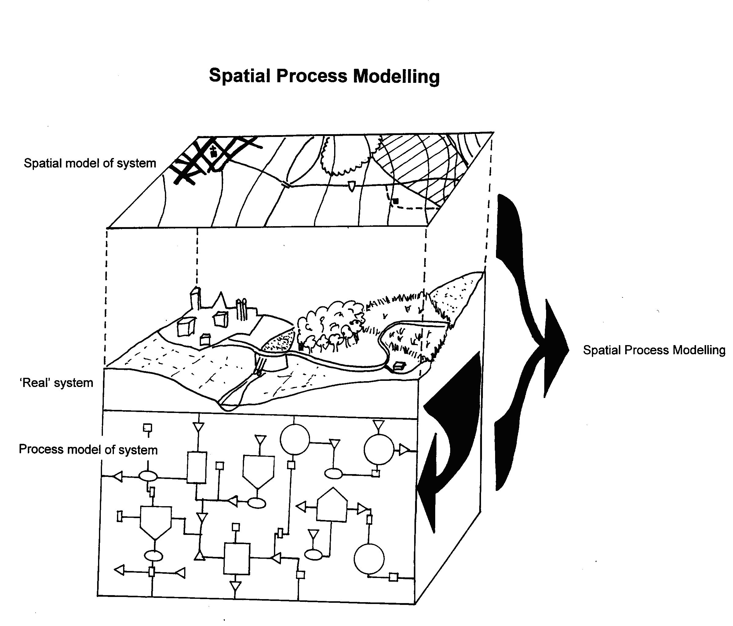
Here are some extracts from my 1997 PhD (summarised in this 1996 paper which has most of these references). In it I proposed a participatory decision making model and developed a “Spatial process modelling system” to facilitate this.
This model combines features of the decision-making models in a way that may reduce conflict while allowing better consideration of biophysical processes. Developing a ‘model for experiment’ rather than relying on an initial problem definition acknowledges that complete understanding is not possible, especially at the outset. This may take into account differing views of how a system operates. It also allows iteration between the potential solutions and negotiation. It is proposed that this structure be encompassed in a ‘decision building environment’ in which computing plays an important role.
Many environmental problems are “wicked” (McNamee, Bunnell et al. 1986 p 395), being particularly intransigent in terms of understanding and computing. This, though, is no excuse for what Jeffers (1988 p 48) called “post-hoc inadequacies”: poor model understanding and data propped up by fancy computer based techniques.
Two major forms of issue can be identified in environmental management. The first is that over the siting of particular noxious land uses, the “Not In My BackYard” problem (NIMBY or Locally Unwanted Land Use, LULU; Brion 1991). Such problems are suited to traditional decision-making and to the array of tools currently available. Opposing groups present their graphs and maps in order to convince decision-makers. These conflicts are also well served by bargaining techniques (computerized or not) where a residents’ group may be able to negotiate the establishment of a park on a corner of a large industrial development (eg. Baccow and Wheeler 1984). Tools such as geographic information systems (GIS) may be of use in such situations (McCloy 1995).
Regional Environmental Decision-Making (REDM) forms a second group of issues. These issues are those which may be considered to be of regional significance and include decisions about grazing practices, the introduction of alien organisms, the impact of tourism and so on.Butler (1991 p 42) discussed how uncertainty is endemic to decision-making: “if there was no uncertainty as to the course of action to take, there would be no decision to make”. Uncertainty in REDM exists in the definition of goals such as the ambiguous ‘sustainability’, in variously defined measures such as ‘biodiversity’, in predicting the environment, in understanding, and in the error associated with statements about location. Lowes and Walker (1995 p 5) write of environmental data being “invariably partial and inadequate” yet decision-makers are faced with “overwhelming data of limited utility”. Walters (1986) argued that all “key management decisions are essentially gambles”, he suggested “embracing uncertainty” and using it to “stimulate imaginative thinking” (p159).
The concept of sustainability implies a balancing of economic, ecological and social factors, and these are not readily comparable through simple overlay. One cannot estimate the economic loss by degradation of a type of landscape unit in the high country simply by calculating the area and assigning the relevant percentage of loss in total production. Actually, the problem here is that one can, especially in a GIS. Again, the technical facility is ahead of understanding.
From an ecological approach it may be useful to acknowledge that environmental processes are dynamic. Responses to change – defined in ecological terms such as ‘stability’, ‘resilience’ and ‘thresholds’ – are especially applicable to REDM (Marten 1988; Freidel 1991; Laycock 1991; Grimm, Schmidt et al. 1992). In land management terms, it may not matter if the percentage cover of bare ground increases during drought. What does matter is if it does not recover (Stafford Smith and Pickup 1990; Pickup and Chewings 1994) or if it is significantly worse than similar areas experiencing similar conditions (Mann 1995). Effort should be placed at designing outputs that reflect the dynamic nature of the environment. The core and buffer maps of Millington (1992) demonstrate how land cover maps with dynamic elements of land cover built into them are more useful than simple thematic maps. Often the model that created the map is more relevant than the output itself.
Of interest is the question whether the tool-boxes available are suitable as the underlying system for developing such “good models” that allow both parsimony and rigour. Despite the problems already identified the answer is affirmative but conditional; some changes are needed. Ball (1994) points out that while the GIS technologies were developed to answer ‘what is?’ queries, we are now asking ‘how is?’ and ‘why is?’ questions and Berry (1993 p 72) argued that “environmental modellers are pushing at the frontiers of GIS technology”. (note this is now an old quote but I think it still applies)
Hutchinson (1965) described an ‘ecological theatre’, to which Wiens (1989 p 385) added that “to understand the drama we must view it at an appropriate scale”. Choosing the appropriate scale may be difficult because as Hutchinson pointed out, the environment should be considered “a hypervolume in hyperspace”. Computer systems should therefore be designed along hierarchical lines with a continuum of scales in time and space.
Sustainability can be considered at many scales: from analysis of points in a farmer’s field to global change models. It may be thought, then, that technologies such as GIS would be well suited to the task of examining the patterns (and thus the processes) involved. With little effort a pattern can be examined at 1:5000 then zoomed out to examine the same features at 1:250,000. This may work well for facilities’ management, as in examining the shape of a road or the distribution of electricity transformers, and can lead to interesting technical issues such as line generalisation (Jones and Abraham 1986), but may not be appropriate in environmental management.Allen et al. (1995) discussed how the work performed by Landcare Research in the high country involves a participatory approach. They aimed to construct a structured library of knowledge based tools which both farmers and researchers may use as a source of advice or a starting point for discussion. This, they argued, recognises the researcher, extension personnel and users as “forming elements of one agricultural information system”. Discussions and detailed interviews are “designed to seek the active co-operation of participants in developing a common understanding of the context in which any individual piece of information becomes relevant”.
The previous chapter examined current approaches in support of Regional Environmental Decision-Making (REDM). The approaches that were considered to be most promising were Geographic Information Systems (GIS), and visual interactive modelling systems (VIMS). While GIS is deficient in facilitating modelling (including time) and in human performance factors, it is more successful when combined with cartographic modelling techniques. The limitations of the GIS approach are the very factors for which VIMS excels. VIMS primarily lacks only the ability to include spatial information. This chapter examines the theoretical potential of combining the two approaches.
Such a combined system is referred to as Spatial Process Modelling (SPM, Figure 36). This can be seen as a metaphor for the problem at hand. Both process and spatial modelling are projections of the real world but both are considerable abstractions. It is proposed that a modelling system which combines the two approaches will better approximate the ‘real world’ and allow improved decision-making.


August 20th, 2012 → 4:31 pm
[…] I’ve long been looking for approaches that use gameplay to engage in sustainability. I’ve previously been disappointed in a lack of systems thinking, and decisions in game design that damage a sustainable game’s utility. While participatory model development rather than gameplay, this was premise of my PhD Spatial Process Modelling. […]