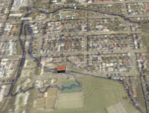
We’re just starting a major project to visualise every Dunedin building, ever. We’re aiming for a 3D immersive environment for any given date (perhaps with a timeline slider). In addition to the general coolness and education value, we’re hoping that it can be used as a modelling tool, say if some wants a new development to fit in with a heritage precinct.
I report it here on the basis that built heritage forms a part of our environment, and thinking about history a pretty good start for thinking about future. I’ve got three Bachelor of Information Technology students from Otago Polytechnic working with me on this (sustainability by stealth? – indeed).
In 1847, Charles Kettle produced a map showing his vision for Dunedin, its suburbs and port. His was a colonial city juxtaposing a formal human order with dramatic views of the surrounding land and seascapes. Dunedin’s eminences and thoroughfares sported many of the country’s finest schools, seminaries, and houses. With their views of the Temple Plain, hills and harbour, these were the dress circle seats in the Romantic City. Few urban places anywhere have such vistas. Kettle’s plan was realized and built—not perfectly, but effectively evoking his vision. (Peter Entwhistle).
Other New Zealand cities were as ambitiously planned (Auckland, Wellington, and Christchurch), but none remained as true to their original plans as Dunedin. Why? Perhaps it was Kettle’s unique and workable vision which meshed city and environs into a single entity: streets that ended with vistas of harbour and hills; outlooks that drew the eye from native bush to burgeoning town, thence seaward. And perhaps it was his plan, combined with the early Scottish settlers in Dunedin, whose determination to carry out Kettle’s plan was supported by newly discovered gold. Whatever the combination, the result is a city unique in New Zealand.
Saving and sharing this city is the purpose of the proposed project: eHeritageDunedin. This interactive, 360-degree, dynamic computer mapping project will be built on Kettle’s original plan for the city, but also contain digital modelling of the evolution of the city, from its earliest days to the present. Further, it will illustrate what the pre-Colonial Maori settlement may have looked like.
This project has these goals:
• Future city planning can be based on a dynamic model of Kettle’s original plan. The preservation of views and vistas will be enhanced through the 3-D modelling of the city. Further, because eHeritageDunedin will be dynamic, it will allow models of new building projects to be viewed and assessed within their environmental context .
• Educational projects concerning Dunedin’s geography and history will be enhanced by the 3-D depictions both of Dunedin’s origins and of how the city has evolved over 150 years.
• Tourism in Dunedin will be able to utilize eHeritageDunedin as a means of enhancing walking or bus tours of the city.
• New migrants or visitors to the city will be able to acclimate more readily to Dunedin, having seen the city, not as a two-dimensional map or as photos in a brochure, but as a 3-dimensional landscape, with hills and valleys, suburbs and parklands, highways and harbours.
• eHeritageDunedin will present Dunedin to the world. Dunedin’s success as a Beautiful City will be demonstrated at the click of the mouse. Those wishing to research the city will be able to see it as it really is, either as a whole, or by isolating and pulling up specific features.
How are we doing it? A mashup (thanks Leigh – great link) of GoogleMaps, Coldfusion and Torque (to name a few…).
Again, if anyone’s counting: this project contributes to the Computing for Sustainability agenda items 7 (resources) , 10 (Frame “for sustainability” as a core driver for research) and 12 (awareness activities).

leighblackall
August 16, 2007
Big time wow factor with this Sam. It’ll be great to witness its progress through your blog